 |
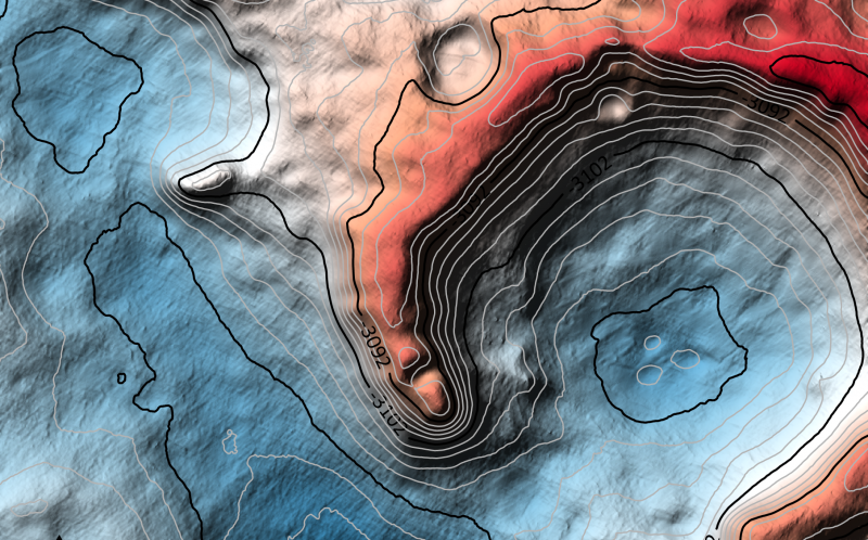
| Here’s a piece of one of the new 3-D models just created to help ESA’s Rosalind Franklin rover explore Mars in 2021. The models are so detailed that they show, for example, as dune ripples inside craters, as you see here. Image via TU Dortmund/ NASA/ JPL-Caltech/ Europlanet. |
How do modern-day space explorers prepare
to search an unknown terrain? Never mind that the explorers are robots,
and that the preparers are space scientists and engineers. Next summer,
an ambitious new mission to Mars is scheduled to launch. The ExoMars mission of the European Space Agency (ESA) will carry the robotic Rosalind Franklin rover to Mars. The rover will search for evidence of past Martian life in Oxia Planum, a large plain rich in clays and containing an old river delta. How do they prepare? A team of scientists at TU Dortmund University in Germany has created extremely detailed 3-D models of the landing location. These scientists said
on September 16, 2019 that they want to use the models to understand
the geography and geological characteristics of this unexplored region
on Mars, and to help plan the path of the rover.
The 3-D models are called Digital Terrain Models (DTMs). They’re a variation of Digital Elevation Models (DEMs)
used by space scientists to understand planets, moons and asteroids.
These particular maps have a resolution of about 25 centimeters per
pixel. One of scientists, Kay Wohlfarth, presented them at last week’s international meeting of astronomers in Geneva, Switzerland.
So how were the models created?
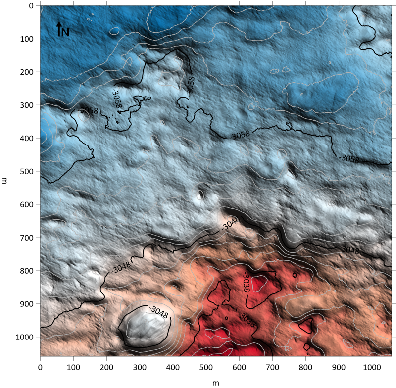 |
| One of the test 3-D models of terrain on Mars. Image via TU Dortmund/NASA/JPL-Caltech/Europlanet Society. |
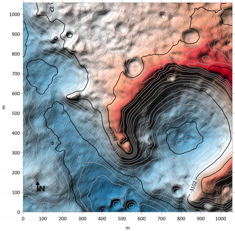 |
| Another test 3-D models of terrain on Mars. Image via TU Dortmund/NASA/JPL-Caltech/Europlanet Society. |
First, they use high-resolution imagery of Mars’ surface from the HiRISE camera on NASA’s Mars Reconnaissance Orbiter (MRO).
That imagery is then applied to the classic stereo method of combining
two images taken from slightly different angles, in order to create a 3D
image of the landscape. But those kinds of stereo techniques can be
limited when it comes to dusty and sandy surfaces – basically
featureless – in locations like the Rosalind Franklin landing site, Oxia
Planum. By necessity, the landing site is relatively flat to help
ensure a safe landing.
The DTMs were then further enhanced by using a technique called Shape from Shading in
which the intensity of reflected light in the image is translated into
information on surface slopes. The slope data is combined with the
stereo imagery, providing a much better estimate of the 3-D surface,
while achieving the best resolution possible in the reconstructed
landscape.
The resulting models give the scientists a much more detailed view of the landing region. As Wohlfarth explained:
With the technique, even small-scale details such as dune ripples inside craters and rough bedrock can be reproduced.
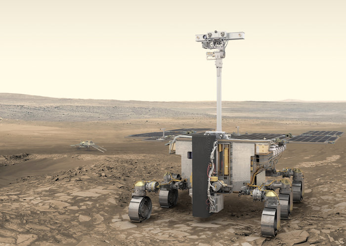 |
| Artist’s illustration of the Rosalind Franklin rover on Mars, part of ESA’s ExoMars mission. Image via ESA/ATG medialab. |
Marcel Hess, first author of the study, said:
We have taken special care over the interaction between light and the Martian surface. Areas that are tilted towards the sun appear brighter and areas that are facing away appear darker. Our approach uses a joint reflectance and atmospheric model that incorporates reflection by the surface as well as atmospheric effects that diffuse and scatter light.
These new models will be a great aid to the rover as it navigates the landscape, looking for the best places to study with its array of instruments.
Not only will the rover examine rocks and soil, it will also be able to
drill up to two meters (six feet) into the subsurface, searching for
possible biosignatures, chemical traces of past life. Samples will be
delivered to the on-board laboratory for analysis.
PanCam, with its stereo and high-resolution
cameras, will provide detailed views of interesting features in both
visible and near-infrared wavelengths. Spectrometers will determine what
rocks are composed of, and how much they were affected by water.
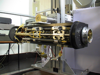 |
| The rover’s drill in a clean room on Earth, in the stowed position. The drill will be able to penetrate down to two meters (six feet) into the subsurface. Image via ESA. |
According to Jorge Vago, ESA’s ExoMars rover project scientist:
Our rover has really taken shape. We have an incredibly powerful scientific payload to explore the surface and subsurface of Mars on our quest to find biosignatures.
ExoMars will be an exciting mission, and along with NASA’s upcoming 2020 rover, the first since the Viking mission
in the 1970s/1980s to look directly for evidence of life. The rover is
expected to launch sometime between July 26 and August 13, 2020 on a
Russian Proton-M launcher, arriving at Mars in March 2021.
More information about ExoMars mission is available on the mission website.
Bottom line: New 3-D models of the Martian terrain will help the Rosalind Franklin rover search for life on Mars in 2021.
Paul Scott Anderson
No comments:
Post a Comment
Note: Only a member of this blog may post a comment.